


20110910- l a P icherie

doudet
User
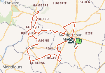

Length
26 km

Max alt
163 m

Uphill gradient
266 m
Km-Effort
30 km

Min alt
69 m

Downhill gradient
267 m
Boucle
Yes
Creation date :
2019-09-15 06:48:21.244
Updated on :
2019-09-15 06:48:21.244
--
Difficulty : Unknown

FREE GPS app for hiking
 SityTrail
IGN / Geographical institutes
SityTrail Plus
The world is yours!
About
Trail On foot of 26 km to be discovered at Pays de la Loire, Mayenne, Martigné-sur-Mayenne. This trail is proposed by doudet.
Positioning
Country:
France
Region :
Pays de la Loire
Department/Province :
Mayenne
Municipality :
Martigné-sur-Mayenne
Location:
Unknown
Start:(Dec)
Start:(UTM)
673908 ; 5339549 (30U) N.
Comments