


Chamrousse : Tour du Lac Robert

manumax
User
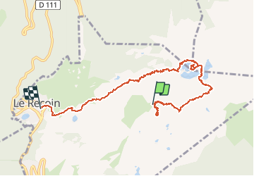

Length
9.8 km

Max alt
2242 m

Uphill gradient
154 m
Km-Effort
13.8 km

Min alt
1665 m

Downhill gradient
722 m
Boucle
No
Creation date :
2019-09-15 09:37:50.92
Updated on :
2020-05-23 11:13:24.824
3h11
Difficulty : Very easy

FREE GPS app for hiking
 SityTrail
IGN / Geographical institutes
SityTrail Plus
The world is yours!
About
Trail Via ferrata of 9.8 km to be discovered at Auvergne-Rhône-Alpes, Isère, Chamrousse. This trail is proposed by manumax.
Positioning
Country:
France
Region :
Auvergne-Rhône-Alpes
Department/Province :
Isère
Municipality :
Chamrousse
Location:
Unknown
Start:(Dec)
Start:(UTM)
728482 ; 5001059 (31T) N.
Comments