Trail Running Rivière-sur-Tarn - rectif parcours 12 - Photo
© OpenStreetMap contributors
Length
Length
12.4 km
Max alt
Max alt
841 m
Uphill gradient
Uphill gradient
544 m
Km-Effort
Km-Effort  
19.7 km
Min alt
Min alt
393 m
Downhill gradient
Downhill gradient
544 m
Boucle
Boucle
Yes
Creation date :
2014-12-10 00:00:00.0
Updated on :
2014-12-10 00:00:00.0

(0 Reviews)

Running
Running
--
Difficulty : Medium

Scan this QR Code to open this trail in the SityTrail application

FREE GPS app for hiking

Logo SityTrail SityTrail

IGN / Geographical institutes

Download SityTrail from the App Store Download SityTrail from Google Play

Logo SityTrail SityTrail World

The world is yours!

Download SityTrail from the App Store Download SityTrail from Google Play Download SityTrail on Huawei AppGallery

About

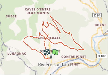
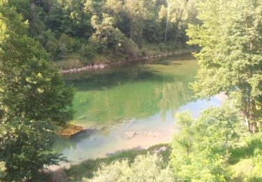
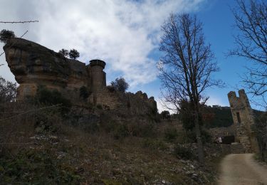
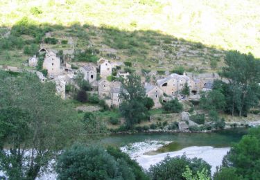
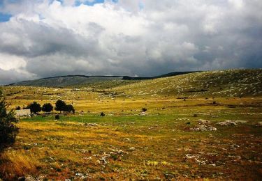
Trail Running of 12.4 km to be discovered at Occitania, Aveyron, Rivière-sur-Tarn. This trail is proposed by ginomania.

Description

Total: 12.5km

Elevation profile

Positioning

Country:
France
Region :
Occitania
Department/Province :
Aveyron
Municipality :
Rivière-sur-Tarn
Location:
Unknown
Start:(UTM)
510421 ; 4893070 (31T) N.

Trails nearby

Trail Walking Mostuéjouls - J7: Mostuéjouls-Millau-150522 - Photo
Walking
canardDenis

Walking

Medium
Mostuéjouls, Occitania, Aveyron, France
22 km | 31 km-effort
6h 57min
No
Trail Walking Rivière-sur-Tarn - Fontaneilles, château de Peyrerade, Piedestal - Photo
Walking
francislassauce

Walking

Difficult
Rivière-sur-Tarn, Occitania, Aveyron, France
7.8 km | 12.7 km-effort
3h 36min
Yes
Trail Walking La Cresse - la cresse, belvédère de caylus - Photo
Walking
francislassauce

Walking

Medium
La Cresse, Occitania, Aveyron, France
6.9 km | 11.3 km-effort
3h 12min
Yes
Trail Trail Mostuéjouls - Le Rozier - Photo
Trail
Atchoum26

Trail

Very easy
Mostuéjouls, Occitania, Aveyron, France
9.2 km | 13.3 km-effort
1h 41min
No
Trail Walking Rivière-sur-Tarn - Puech de Fontaneilles - Photo
Walking
ZITO12

Walking

Easy
Rivière-sur-Tarn, Occitania, Aveyron, France
10.4 km | 16.2 km-effort
4h 53min
Yes
Trail Walking Rivière-sur-Tarn - Grands Causses - Peyrelade - Chateau-vignes-forêt - 2016 09 09 - Photo
Walking
Orcal37

Walking

Medium
Rivière-sur-Tarn, Occitania, Aveyron, France
9.9 km | 15.2 km-effort
3h 30min
Yes
Trail Walking Compeyre - les 3 chateaux - Photo
Walking
colber

Walking

Very easy
Compeyre, Occitania, Aveyron, France
16.3 km | 22 km-effort
3h 53min
Yes
Trail Mountain bike Mostuéjouls - Causse Méjean - Gorges du Tarn - Photo
Mountain bike
tracegps

Mountain bike

Very difficult
(2)
Mostuéjouls, Occitania, Aveyron, France
87 km | 113 km-effort
12h 0min
Yes
Trail Mountain bike Aguessac - GéoBike - Tour des Grands Causses - édition 2009 - Photo
Mountain bike
tracegps

Mountain bike

Very difficult
Aguessac, Occitania, Aveyron, France
225 km | 295 km-effort
0h 0min
Yes


Close
My subscriptions