


col de sabions

kenleggat
User
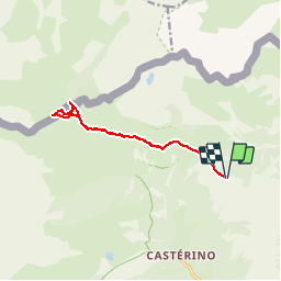

Length
11.5 km

Max alt
2351 m

Uphill gradient
397 m
Km-Effort
16.8 km

Min alt
2037 m

Downhill gradient
396 m
Boucle
Yes
Creation date :
2019-09-16 09:47:28.164
Updated on :
2019-09-16 15:55:15.312
5h58
Difficulty : Very easy

FREE GPS app for hiking
 SityTrail
IGN / Geographical institutes
SityTrail Plus
The world is yours!
About
Trail Walking of 11.5 km to be discovered at Provence-Alpes-Côte d'Azur, Maritime Alps, Tende. This trail is proposed by kenleggat.
Positioning
Country:
France
Region :
Provence-Alpes-Côte d'Azur
Department/Province :
Maritime Alps
Municipality :
Tende
Location:
Unknown
Start:(Dec)
Start:(UTM)
381623 ; 4885810 (32T) N.
Comments