


avéne

pipette12
User
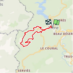

Length
12.4 km

Max alt
775 m

Uphill gradient
475 m
Km-Effort
18.8 km

Min alt
373 m

Downhill gradient
476 m
Boucle
Yes
Creation date :
2014-12-10 00:00:00.0
Updated on :
2014-12-10 00:00:00.0
4h06
Difficulty : Very easy

FREE GPS app for hiking
 SityTrail
IGN / Geographical institutes
SityTrail Plus
The world is yours!
About
Trail Walking of 12.4 km to be discovered at Occitania, Hérault, Avène. This trail is proposed by pipette12.
Description
foret des mont d'orb
Positioning
Country:
France
Region :
Occitania
Department/Province :
Hérault
Municipality :
Avène
Location:
Unknown
Start:(Dec)
Start:(UTM)
507926 ; 4844833 (31T) N.
Comments