


potigny 12 kms bréche au diable 2018

aubinjoel
User
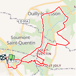

Length
13 km

Max alt
167 m

Uphill gradient
213 m
Km-Effort
15.9 km

Min alt
80 m

Downhill gradient
213 m
Boucle
Yes
Creation date :
2019-09-16 18:22:10.239
Updated on :
2019-09-16 18:22:25.489

FREE GPS app for hiking
 SityTrail
IGN / Geographical institutes
SityTrail Plus
The world is yours!
About
Trail of 13 km to be discovered at Normandy, Calvados, Potigny. This trail is proposed by aubinjoel.
Positioning
Country:
France
Region :
Normandy
Department/Province :
Calvados
Municipality :
Potigny
Location:
Unknown
Start:(Dec)
Start:(UTM)
701943 ; 5427754 (30U) N.
Comments