


tréves

pipette12
User
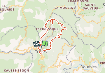

Length
14.7 km

Max alt
939 m

Uphill gradient
773 m
Km-Effort
25 km

Min alt
559 m

Downhill gradient
767 m
Boucle
Yes
Creation date :
2014-12-10 00:00:00.0
Updated on :
2014-12-10 00:00:00.0
1h40
Difficulty : Very easy

FREE GPS app for hiking
 SityTrail
IGN / Geographical institutes
SityTrail Plus
The world is yours!
About
Trail Other activity of 14.7 km to be discovered at Occitania, Gard, Trèves. This trail is proposed by pipette12.
Description
les gorges du trévezel
Positioning
Country:
France
Region :
Occitania
Department/Province :
Gard
Municipality :
Trèves
Location:
Unknown
Start:(Dec)
Start:(UTM)
531172 ; 4880690 (31T) N.
Comments