avéne

pipette12
User
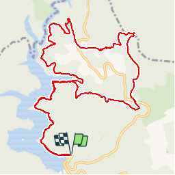

Length
15.5 km

Max alt
736 m

Uphill gradient
520 m
Km-Effort
22 km

Min alt
433 m

Downhill gradient
512 m
Boucle
Yes
Creation date :
2014-12-10 00:00:00.0
Updated on :
2014-12-10 00:00:00.0
4h56
Difficulty : Very easy

FREE GPS app for hiking
 SityTrail
IGN / Geographical institutes
SityTrail Plus
The world is yours!
About
Trail Walking of 15.5 km to be discovered at Occitania, Hérault, Avène. This trail is proposed by pipette12.
Description
bord du barrage et col entre avéne et ceilhes
Positioning
Country:
France
Region :
Occitania
Department/Province :
Hérault
Municipality :
Avène
Location:
Unknown
Start:(Dec)
Start:(UTM)
507695 ; 4846120 (31T) N.
Comments