


rabou

BLANCHET
User
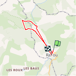

Length
9.8 km

Max alt
1399 m

Uphill gradient
783 m
Km-Effort
20 km

Min alt
1041 m

Downhill gradient
814 m
Boucle
No
Creation date :
2019-09-17 06:32:40.18
Updated on :
2019-09-17 16:31:50.772
1h28
Difficulty : Very easy

FREE GPS app for hiking
 SityTrail
IGN / Geographical institutes
SityTrail Plus
The world is yours!
About
Trail Walking of 9.8 km to be discovered at Provence-Alpes-Côte d'Azur, Hautes-Alpes, Rabou. This trail is proposed by BLANCHET.
Positioning
Country:
France
Region :
Provence-Alpes-Côte d'Azur
Department/Province :
Hautes-Alpes
Municipality :
Rabou
Location:
Unknown
Start:(Dec)
Start:(UTM)
262438 ; 4942264 (32T) N.
Comments