


V2019 1.10 Tintry randonnée douce

clabidault
User
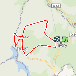

Length
8 km

Max alt
472 m

Uphill gradient
117 m
Km-Effort
9.5 km

Min alt
395 m

Downhill gradient
118 m
Boucle
Yes
Creation date :
2019-09-18 06:53:04.203
Updated on :
2019-10-02 19:05:51.153
--
Difficulty : Very easy

FREE GPS app for hiking
 SityTrail
IGN / Geographical institutes
SityTrail Plus
The world is yours!
About
Trail On foot of 8 km to be discovered at Bourgogne-Franche-Comté, Saône-et-Loire, Tintry. This trail is proposed by clabidault.
Description
24 Participants parcours modifié en raison de la pluie
Positioning
Country:
France
Region :
Bourgogne-Franche-Comté
Department/Province :
Saône-et-Loire
Municipality :
Tintry
Location:
Unknown
Start:(Dec)
Start:(UTM)
613768 ; 5198479 (31T) N.
Comments