


lac de peyrefitte

kenleggat
User
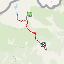

Length
4.8 km

Max alt
2334 m

Uphill gradient
270 m
Km-Effort
8.7 km

Min alt
2037 m

Downhill gradient
378 m
Boucle
No
Creation date :
2019-09-18 07:55:17.63
Updated on :
2019-09-18 12:10:13.264
3h23
Difficulty : Very easy

FREE GPS app for hiking
 SityTrail
IGN / Geographical institutes
SityTrail Plus
The world is yours!
About
Trail Walking of 4.8 km to be discovered at Provence-Alpes-Côte d'Azur, Maritime Alps, Tende. This trail is proposed by kenleggat.
Positioning
Country:
France
Region :
Provence-Alpes-Côte d'Azur
Department/Province :
Maritime Alps
Municipality :
Tende
Location:
Unknown
Start:(Dec)
Start:(UTM)
380314 ; 4887609 (32T) N.
Comments