


bof bao

ballay
User
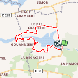

Length
7.8 km

Max alt
106 m

Uphill gradient
105 m
Km-Effort
9.2 km

Min alt
83 m

Downhill gradient
107 m
Boucle
Yes
Creation date :
2019-09-18 13:04:25.171
Updated on :
2019-09-18 15:39:21.811
2h34
Difficulty : Very easy

FREE GPS app for hiking
 SityTrail
IGN / Geographical institutes
SityTrail Plus
The world is yours!
About
Trail Walking of 7.8 km to be discovered at Brittany, Ille-et-Vilaine, Baulon. This trail is proposed by ballay.
Description
baulon bof
Positioning
Country:
France
Region :
Brittany
Department/Province :
Ille-et-Vilaine
Municipality :
Baulon
Location:
Unknown
Start:(Dec)
Start:(UTM)
578460 ; 5316786 (30T) N.
Comments