


Chemin du douanier Boulouris a Temple des amoureux

henriantoine
User

Length
2.6 km

Max alt
11 m

Uphill gradient
24 m
Km-Effort
2.9 km

Min alt
0 m

Downhill gradient
27 m
Boucle
No
Creation date :
2019-09-18 12:48:00.0
Updated on :
2019-09-22 15:51:42.984
1h49
Difficulty : Difficult

FREE GPS app for hiking
 SityTrail
IGN / Geographical institutes
SityTrail Plus
The world is yours!
About
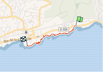
Trail Walking of 2.6 km to be discovered at Provence-Alpes-Côte d'Azur, Var, Saint-Raphaël. This trail is proposed by henriantoine.
Description
Ces 10 dernières années ont bien dégradé le sentier ce qui rend le niveau de difficulté plus élevé mais le charme est toujours au rendez-vous
Photos


Positioning
Country:
France
Region :
Provence-Alpes-Côte d'Azur
Department/Province :
Var
Municipality :
Saint-Raphaël
Location:
Unknown
Start:(Dec)
Start:(UTM)
323786 ; 4809507 (32T) N.
Comments