


de TOURNADOUS à TOURNADOUS

pipette12
User
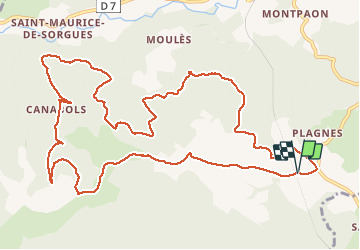

Length
14.7 km

Max alt
761 m

Uphill gradient
364 m
Km-Effort
19.5 km

Min alt
490 m

Downhill gradient
366 m
Boucle
Yes
Creation date :
2014-12-10 00:00:00.0
Updated on :
2014-12-10 00:00:00.0
4h22
Difficulty : Very easy

FREE GPS app for hiking
 SityTrail
IGN / Geographical institutes
SityTrail Plus
The world is yours!
About
Trail Walking of 14.7 km to be discovered at Occitania, Aveyron, Fondamente. This trail is proposed by pipette12.
Description
RANDONNÉE QUE JE CONSEILLE DE FAIRE À L'ÉPOQUE DES CHAMPIGNONS ET DES CHATAIGNES
Positioning
Country:
France
Region :
Occitania
Department/Province :
Aveyron
Municipality :
Fondamente
Location:
Unknown
Start:(Dec)
Start:(UTM)
509461 ; 4854967 (31T) N.
Comments