


Monts de Blond

Arnaud Dejean
User
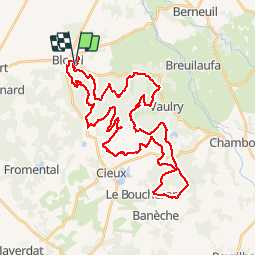

Length
46 km

Max alt
496 m

Uphill gradient
1041 m
Km-Effort
60 km

Min alt
300 m

Downhill gradient
1040 m
Boucle
Yes
Creation date :
2019-09-19 07:53:16.232
Updated on :
2019-09-19 12:49:09.47
3h28
Difficulty : Difficult

FREE GPS app for hiking
 SityTrail
IGN / Geographical institutes
SityTrail Plus
The world is yours!
About
Trail Mountain bike of 46 km to be discovered at New Aquitaine, Haute-Vienne, Blond. This trail is proposed by Arnaud Dejean.
Positioning
Country:
France
Region :
New Aquitaine
Department/Province :
Haute-Vienne
Municipality :
Blond
Location:
Unknown
Start:(Dec)
Start:(UTM)
347070 ; 5100697 (31T) N.
Comments