


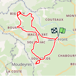
J4 Saint Front

Monjean
User

Length
19.6 km

Max alt
1253 m

Uphill gradient
495 m
Km-Effort
26 km

Min alt
1092 m

Downhill gradient
494 m
Boucle
Yes
Creation date :
2019-09-19 07:59:10.878
Updated on :
2019-09-19 15:07:15.898
7h06
Difficulty : Very easy

FREE GPS app for hiking
 SityTrail
IGN / Geographical institutes
SityTrail Plus
The world is yours!
About
Trail Walking of 19.6 km to be discovered at Auvergne-Rhône-Alpes, Haute-Loire, Saint-Front. This trail is proposed by Monjean.
Positioning
Country:
France
Region :
Auvergne-Rhône-Alpes
Department/Province :
Haute-Loire
Municipality :
Saint-Front
Location:
Unknown
Start:(Dec)
Start:(UTM)
590165 ; 4981077 (31T) N.
Comments