


G2 Dennevy

LUCIE2016
User
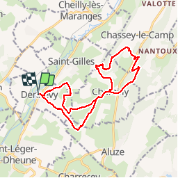

Length
16.4 km

Max alt
426 m

Uphill gradient
426 m
Km-Effort
22 km

Min alt
236 m

Downhill gradient
425 m
Boucle
Yes
Creation date :
2019-09-20 11:51:28.034
Updated on :
2019-09-20 15:40:50.084
3h37
Difficulty : Very easy

FREE GPS app for hiking
 SityTrail
IGN / Geographical institutes
SityTrail Plus
The world is yours!
About
Trail Walking of 16.4 km to be discovered at Bourgogne-Franche-Comté, Saône-et-Loire, Dennevy. This trail is proposed by LUCIE2016.
Positioning
Country:
France
Region :
Bourgogne-Franche-Comté
Department/Province :
Saône-et-Loire
Municipality :
Dennevy
Location:
Unknown
Start:(Dec)
Start:(UTM)
625610 ; 5191618 (31T) N.
Comments