


Le Moucherotte par le vertige des cimes - 22 sept 2019

morganee
User
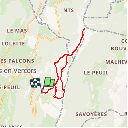

Length
13.1 km

Max alt
1885 m

Uphill gradient
652 m
Km-Effort
22 km

Min alt
1374 m

Downhill gradient
655 m
Boucle
Yes
Creation date :
2019-09-21 08:45:47.682
Updated on :
2019-09-21 13:31:32.853
4h00
Difficulty : Medium

FREE GPS app for hiking
 SityTrail
IGN / Geographical institutes
SityTrail Plus
The world is yours!
About
Trail Walking of 13.1 km to be discovered at Auvergne-Rhône-Alpes, Isère, Lans-en-Vercors. This trail is proposed by morganee.
Positioning
Country:
France
Region :
Auvergne-Rhône-Alpes
Department/Province :
Isère
Municipality :
Lans-en-Vercors
Location:
Unknown
Start:(Dec)
Start:(UTM)
705296 ; 4999215 (31T) N.
Comments