


2013-09-14 St Julien de Mailloc AG cap-rando

jchezlemas
User
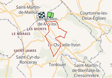

Length
10.2 km

Max alt
159 m

Uphill gradient
201 m
Km-Effort
12.9 km

Min alt
72 m

Downhill gradient
201 m
Boucle
Yes
Creation date :
2014-12-10 00:00:00.0
Updated on :
2014-12-10 00:00:00.0
2h46
Difficulty : Easy

FREE GPS app for hiking
 SityTrail
IGN / Geographical institutes
SityTrail Plus
The world is yours!
About
Trail Walking of 10.2 km to be discovered at Normandy, Calvados, Valorbiquet. This trail is proposed by jchezlemas.
Positioning
Country:
France
Region :
Normandy
Department/Province :
Calvados
Municipality :
Valorbiquet
Location:
Saint-Julien-de-Mailloc
Start:(Dec)
Start:(UTM)
304209 ; 5439921 (31U) N.
Comments