


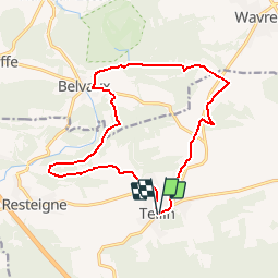
TELLIN

fputters
User

Length
14.4 km

Max alt
305 m

Uphill gradient
275 m
Km-Effort
18.1 km

Min alt
165 m

Downhill gradient
273 m
Boucle
Yes
Creation date :
2019-09-22 14:54:15.025
Updated on :
2019-09-22 14:55:09.586
--
Difficulty : Very easy

FREE GPS app for hiking
 SityTrail
IGN / Geographical institutes
SityTrail Plus
The world is yours!
About
Trail On foot of 14.4 km to be discovered at Wallonia, Luxembourg, Tellin. This trail is proposed by fputters.
Description
A PARTIR D UNE RANDO SITY TRAIL (un peu allongée)
Positioning
Country:
Belgium
Region :
Wallonia
Department/Province :
Luxembourg
Municipality :
Tellin
Location:
Tellin
Start:(Dec)
Start:(UTM)
658630 ; 5549995 (31U) N.
Comments