


Amicale_Tarare_Sauvages_240919_16

d.rognon
User
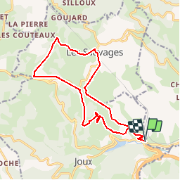

Length
16.2 km

Max alt
793 m

Uphill gradient
645 m
Km-Effort
25 km

Min alt
434 m

Downhill gradient
647 m
Boucle
Yes
Creation date :
2019-09-22 17:17:11.209
Updated on :
2019-09-22 17:23:51.62
5h08
Difficulty : Difficult

FREE GPS app for hiking
 SityTrail
IGN / Geographical institutes
SityTrail Plus
The world is yours!
About
Trail Walking of 16.2 km to be discovered at Auvergne-Rhône-Alpes, Rhône, Joux. This trail is proposed by d.rognon.
Positioning
Country:
France
Region :
Auvergne-Rhône-Alpes
Department/Province :
Rhône
Municipality :
Joux
Location:
Unknown
Start:(Dec)
Start:(UTM)
608637 ; 5083225 (31T) N.
Comments