


SVRP 2019

astein
User
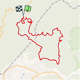

Length
22 km

Max alt
386 m

Uphill gradient
696 m
Km-Effort
31 km

Min alt
15 m

Downhill gradient
696 m
Boucle
Yes
Creation date :
2019-09-23 05:49:52.0
Updated on :
2019-09-23 12:22:46.318
5h41
Difficulty : Difficult

FREE GPS app for hiking
 SityTrail
IGN / Geographical institutes
SityTrail Plus
The world is yours!
About
Trail Walking of 22 km to be discovered at Provence-Alpes-Côte d'Azur, Var, Fréjus. This trail is proposed by astein.
Positioning
Country:
France
Region :
Provence-Alpes-Côte d'Azur
Department/Province :
Var
Municipality :
Fréjus
Location:
Unknown
Start:(Dec)
Start:(UTM)
322260 ; 4818312 (32T) N.
Comments