


Cahors lascabannes

papyveto
User
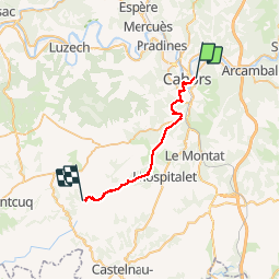

Length
24 km

Max alt
305 m

Uphill gradient
523 m
Km-Effort
31 km

Min alt
110 m

Downhill gradient
453 m
Boucle
No
Creation date :
2019-09-23 06:04:48.0
Updated on :
2019-09-23 18:50:16.137
6h17
Difficulty : Unknown

FREE GPS app for hiking
 SityTrail
IGN / Geographical institutes
SityTrail Plus
The world is yours!
About
Trail Walking of 24 km to be discovered at Occitania, Lot, Cahors. This trail is proposed by papyveto.
Description
Cahors lascabannes
Positioning
Country:
France
Region :
Occitania
Department/Province :
Lot
Municipality :
Cahors
Location:
Unknown
Start:(Dec)
Start:(UTM)
376364 ; 4922943 (31T) N.
Comments