


VESC " LE PEINARD"

ajasse
User
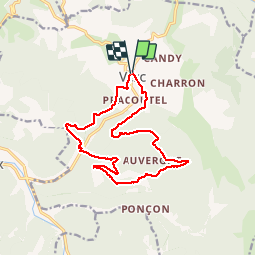

Length
15.3 km

Max alt
966 m

Uphill gradient
620 m
Km-Effort
24 km

Min alt
512 m

Downhill gradient
611 m
Boucle
Yes
Creation date :
2019-09-23 07:50:03.513
Updated on :
2019-09-23 19:22:00.342
5h41
Difficulty : Medium

FREE GPS app for hiking
 SityTrail
IGN / Geographical institutes
SityTrail Plus
The world is yours!
About
Trail Walking of 15.3 km to be discovered at Auvergne-Rhône-Alpes, Drôme, Vesc. This trail is proposed by ajasse.
Description
Très belle randonnée autour de la montagne du Ruy.
Positioning
Country:
France
Region :
Auvergne-Rhône-Alpes
Department/Province :
Drôme
Municipality :
Vesc
Location:
Unknown
Start:(Dec)
Start:(UTM)
670978 ; 4932153 (31T) N.
Comments