


track

Blourouce
User
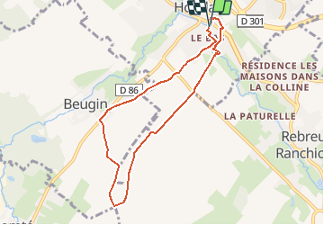

Length
7 km

Max alt
130 m

Uphill gradient
100 m
Km-Effort
8.4 km

Min alt
53 m

Downhill gradient
102 m
Boucle
Yes
Creation date :
2019-09-24 13:01:57.689
Updated on :
2020-02-18 09:53:02.438
1h49
Difficulty : Medium

FREE GPS app for hiking
 SityTrail
IGN / Geographical institutes
SityTrail Plus
The world is yours!
About
Trail Walking of 7 km to be discovered at Hauts-de-France, Pas-de-Calais, Houdain. This trail is proposed by Blourouce.
Positioning
Country:
France
Region :
Hauts-de-France
Department/Province :
Pas-de-Calais
Municipality :
Houdain
Location:
Unknown
Start:(Dec)
Start:(UTM)
467235 ; 5588928 (31U) N.
Comments