


vesc

raygautier
User
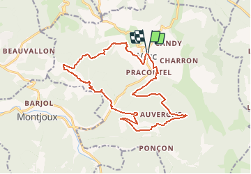

Length
18.9 km

Max alt
1003 m

Uphill gradient
1032 m
Km-Effort
33 km

Min alt
512 m

Downhill gradient
1027 m
Boucle
Yes
Creation date :
2019-09-25 08:38:15.954
Updated on :
2019-09-25 08:39:32.066
--
Difficulty : Very easy

FREE GPS app for hiking
 SityTrail
IGN / Geographical institutes
SityTrail Plus
The world is yours!
About
Trail On foot of 18.9 km to be discovered at Auvergne-Rhône-Alpes, Drôme, Vesc. This trail is proposed by raygautier.
Description
difficile
Positioning
Country:
France
Region :
Auvergne-Rhône-Alpes
Department/Province :
Drôme
Municipality :
Vesc
Location:
Unknown
Start:(Dec)
Start:(UTM)
671006 ; 4932165 (31T) N.
Comments