


gpx-trace

Laurent53
User
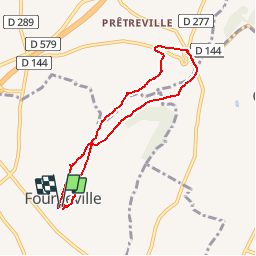

Length
6.7 km

Max alt
118 m

Uphill gradient
127 m
Km-Effort
8.3 km

Min alt
50 m

Downhill gradient
125 m
Boucle
Yes
Creation date :
2019-09-25 12:38:00.841
Updated on :
2019-09-25 12:44:12.043
2h00
Difficulty : Easy

FREE GPS app for hiking
 SityTrail
IGN / Geographical institutes
SityTrail Plus
The world is yours!
About
Trail On foot of 6.7 km to be discovered at Normandy, Calvados, Fourneville. This trail is proposed by Laurent53.
Positioning
Country:
France
Region :
Normandy
Department/Province :
Calvados
Municipality :
Fourneville
Location:
Unknown
Start:(Dec)
Start:(UTM)
299285 ; 5470803 (31U) N.
Comments