


Lauzerte Moissac

papyveto
User
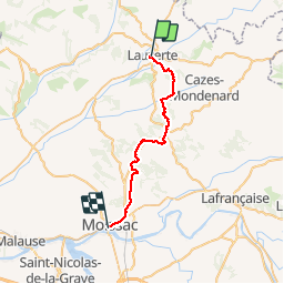

Length
29 km

Max alt
231 m

Uphill gradient
587 m
Km-Effort
37 km

Min alt
72 m

Downhill gradient
716 m
Boucle
No
Creation date :
2019-09-25 06:17:36.0
Updated on :
2019-09-25 14:14:22.847
7h54
Difficulty : Unknown

FREE GPS app for hiking
 SityTrail
IGN / Geographical institutes
SityTrail Plus
The world is yours!
About
Trail Walking of 29 km to be discovered at Occitania, Tarn-et-Garonne, Lauzerte. This trail is proposed by papyveto.
Positioning
Country:
France
Region :
Occitania
Department/Province :
Tarn-et-Garonne
Municipality :
Lauzerte
Location:
Unknown
Start:(Dec)
Start:(UTM)
351194 ; 4901935 (31T) N.
Comments