


GERARDMER3

Clm rs
User
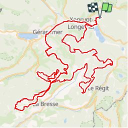

Length
68 km

Max alt
1176 m

Uphill gradient
1988 m
Km-Effort
95 km

Min alt
676 m

Downhill gradient
1989 m
Boucle
Yes
Creation date :
2019-09-25 20:33:35.781
Updated on :
2019-09-25 20:35:40.228
6h06
Difficulty : Very difficult

FREE GPS app for hiking
 SityTrail
IGN / Geographical institutes
SityTrail Plus
The world is yours!
About
Trail Mountain bike of 68 km to be discovered at Grand Est, Vosges, Xonrupt-Longemer. This trail is proposed by Clm rs.
Positioning
Country:
France
Region :
Grand Est
Department/Province :
Vosges
Municipality :
Xonrupt-Longemer
Location:
Unknown
Start:(Dec)
Start:(UTM)
347509 ; 5327837 (32U) N.
Comments