


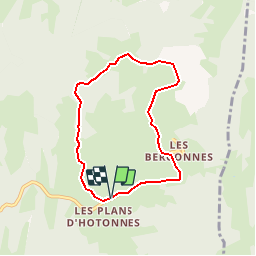
Les Plans d'Hotonnes Les Bergonnes

michel.pegaz
User

Length
6.3 km

Max alt
1188 m

Uphill gradient
165 m
Km-Effort
8.5 km

Min alt
1033 m

Downhill gradient
164 m
Boucle
Yes
Creation date :
2019-09-26 08:06:58.192
Updated on :
2019-09-26 08:18:31.119
--
Difficulty : Very easy

FREE GPS app for hiking
 SityTrail
IGN / Geographical institutes
SityTrail Plus
The world is yours!
About
Trail On foot of 6.3 km to be discovered at Auvergne-Rhône-Alpes, Ain, Haut Valromey. This trail is proposed by michel.pegaz.
Description
Départ les Plans d'Hotonnes par le GRP Tour du Valromey
direction le Gros Frêne point côté 1183 - Granges Charpy - Les Bergonnes
Positioning
Country:
France
Region :
Auvergne-Rhône-Alpes
Department/Province :
Ain
Municipality :
Haut Valromey
Location:
Hotonnes
Start:(Dec)
Start:(UTM)
709061 ; 5101940 (31T) N.
Comments