


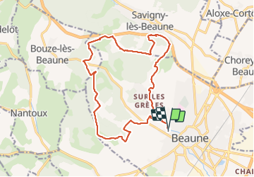
Beaune la montagne st Désiré page 122

grasgilbert
User

Length
17.9 km

Max alt
387 m

Uphill gradient
467 m
Km-Effort
24 km

Min alt
218 m

Downhill gradient
466 m
Boucle
Yes
Creation date :
2019-09-26 07:19:00.481
Updated on :
2021-08-05 15:03:43.764
5h15
Difficulty : Difficult

FREE GPS app for hiking
 SityTrail
IGN / Geographical institutes
SityTrail Plus
The world is yours!
About
Trail Walking of 17.9 km to be discovered at Bourgogne-Franche-Comté, Côte-d'Or, Beaune. This trail is proposed by grasgilbert.
Description
La montagne Saint désiré
Photos


Positioning
Country:
France
Region :
Bourgogne-Franche-Comté
Department/Province :
Côte-d'Or
Municipality :
Beaune
Location:
Unknown
Start:(Dec)
Start:(UTM)
638882 ; 5209698 (31T) N.
Comments