


VAUVERT 27 09 19

Dupuybadonniere
User

Length
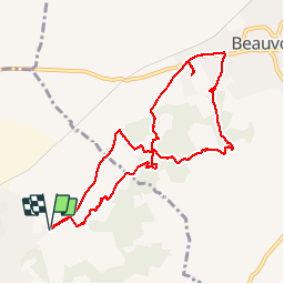
10 km

Max alt
106 m

Uphill gradient
118 m
Km-Effort
11.5 km

Min alt
37 m

Downhill gradient
118 m
Boucle
Yes
Creation date :
2019-09-27 06:48:11.206
Updated on :
2019-09-27 09:57:44.076
2h31
Difficulty : Very easy

FREE GPS app for hiking
 SityTrail
IGN / Geographical institutes
SityTrail Plus
The world is yours!
About
Trail Walking of 10 km to be discovered at Occitania, Gard, Vauvert. This trail is proposed by Dupuybadonniere.
Positioning
Country:
France
Region :
Occitania
Department/Province :
Gard
Municipality :
Vauvert
Location:
Unknown
Start:(Dec)
Start:(UTM)
603849 ; 4839133 (31T) N.
Comments