


villeny_Chateau de la Cantée

lemuid
User
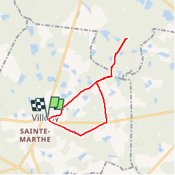

Length
11.3 km

Max alt
148 m

Uphill gradient
96 m
Km-Effort
12.6 km

Min alt
102 m

Downhill gradient
97 m
Boucle
Yes
Creation date :
2019-09-27 07:25:44.683
Updated on :
2019-09-27 13:50:55.225
2h22
Difficulty : Very easy

FREE GPS app for hiking
 SityTrail
IGN / Geographical institutes
SityTrail Plus
The world is yours!
About
Trail Walking of 11.3 km to be discovered at Centre-Loire Valley, Loir-et-Cher, Villeny. This trail is proposed by lemuid.
Positioning
Country:
France
Region :
Centre-Loire Valley
Department/Province :
Loir-et-Cher
Municipality :
Villeny
Location:
Unknown
Start:(Dec)
Start:(UTM)
406572 ; 5275126 (31T) N.
Comments