


Miradoux Lectoure

papyveto
User
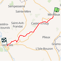

Length
16.5 km

Max alt
214 m

Uphill gradient
311 m
Km-Effort
21 km

Min alt
93 m

Downhill gradient
329 m
Boucle
No
Creation date :
2019-09-28 06:41:04.0
Updated on :
2019-09-28 10:24:15.941
3h42
Difficulty : Unknown

FREE GPS app for hiking
 SityTrail
IGN / Geographical institutes
SityTrail Plus
The world is yours!
About
Trail Walking of 16.5 km to be discovered at Occitania, Gers, Miradoux. This trail is proposed by papyveto.
Positioning
Country:
France
Region :
Occitania
Department/Province :
Gers
Municipality :
Miradoux
Location:
Unknown
Start:(Dec)
Start:(UTM)
320049 ; 4874000 (31T) N.
Comments