


--Rochebrune-- OR-5662397:Rochebrune 16km

thonyc
User GUIDE
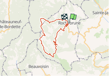

Length
14.6 km

Max alt
942 m

Uphill gradient
591 m
Km-Effort
23 km

Min alt
534 m

Downhill gradient
591 m
Boucle
Yes
Creation date :
2019-09-29 06:46:50.77
Updated on :
2019-10-07 14:44:20.544
4h40
Difficulty : Very difficult

FREE GPS app for hiking
 SityTrail
IGN / Geographical institutes
SityTrail Plus
The world is yours!
About
Trail Walking of 14.6 km to be discovered at Auvergne-Rhône-Alpes, Drôme, Rochebrune. This trail is proposed by thonyc.
Positioning
Country:
France
Region :
Auvergne-Rhône-Alpes
Department/Province :
Drôme
Municipality :
Rochebrune
Location:
Unknown
Start:(Dec)
Start:(UTM)
678996 ; 4911660 (31T) N.
Comments