


Angleur

tchikplouf
User
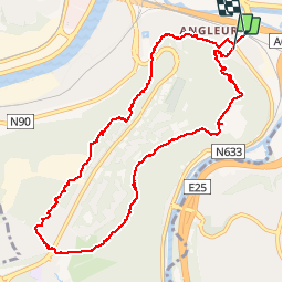

Length
10.3 km

Max alt
240 m

Uphill gradient
231 m
Km-Effort
13.4 km

Min alt
63 m

Downhill gradient
232 m
Boucle
No
Creation date :
2019-09-29 07:28:00.0
Updated on :
2019-09-29 09:40:20.059
2h10
Difficulty : Unknown

FREE GPS app for hiking
 SityTrail
IGN / Geographical institutes
SityTrail Plus
The world is yours!
About
Trail Walking of 10.3 km to be discovered at Wallonia, Liège, Liège. This trail is proposed by tchikplouf.
Positioning
Country:
Belgium
Region :
Wallonia
Department/Province :
Liège
Municipality :
Liège
Location:
Angleur
Start:(Dec)
Start:(UTM)
683899 ; 5609796 (31U) N.
Comments