


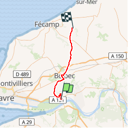
Tancarville

lucmarescot
User

Length
46 km

Max alt
143 m

Uphill gradient
673 m
Km-Effort
55 km

Min alt
28 m

Downhill gradient
696 m
Boucle
No
Creation date :
2019-09-29 07:45:04.0
Updated on :
2019-09-29 12:13:48.238
4h12
Difficulty : Unknown

FREE GPS app for hiking
 SityTrail
IGN / Geographical institutes
SityTrail Plus
The world is yours!
About
Trail Hunting of 46 km to be discovered at Normandy, Seine-Maritime, Tancarville. This trail is proposed by lucmarescot.
Description
Bois ST
Photos


21 photos in total. Please click on a photo to see them all in the gallery.
Positioning
Country:
France
Region :
Normandy
Department/Province :
Seine-Maritime
Municipality :
Tancarville
Location:
Unknown
Start:(Dec)
Start:(UTM)
315676 ; 5485049 (31U) N.
Comments