


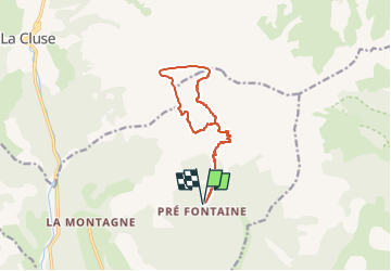
SityTrail - Pas de Paul - Tete de la Cluse

GAPIAN43
User

Length
12.3 km

Max alt
2667 m

Uphill gradient
1334 m
Km-Effort
30 km

Min alt
1365 m

Downhill gradient
1335 m
Boucle
Yes
Creation date :
2019-09-29 18:17:32.393
Updated on :
2022-06-05 18:21:10.785
5h28
Difficulty : Difficult

FREE GPS app for hiking
 SityTrail
IGN / Geographical institutes
SityTrail Plus
The world is yours!
About
Trail Walking of 12.3 km to be discovered at Provence-Alpes-Côte d'Azur, Hautes-Alpes, Montmaur. This trail is proposed by GAPIAN43.
Description
Montée par le pas de Paul, l Tête de Pras Arnaud , Tête de la Cluse. Descente par la Combe de Mai
Positioning
Country:
France
Region :
Provence-Alpes-Côte d'Azur
Department/Province :
Hautes-Alpes
Municipality :
Montmaur
Location:
Unknown
Start:(Dec)
Start:(UTM)
730475 ; 4942855 (31T) N.
Comments