


BREST

trailer.nono
User
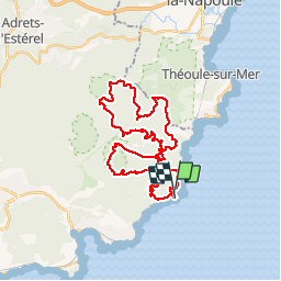

Length
39 km

Max alt
485 m

Uphill gradient
1777 m
Km-Effort
63 km

Min alt
16 m

Downhill gradient
1783 m
Boucle
Yes
Creation date :
2019-09-29 04:58:11.003
Updated on :
2019-09-30 08:31:06.243
5h37
Difficulty : Medium

FREE GPS app for hiking
 SityTrail
IGN / Geographical institutes
SityTrail Plus
The world is yours!
About
Trail Trail of 39 km to be discovered at Provence-Alpes-Côte d'Azur, Var, Saint-Raphaël. This trail is proposed by trailer.nono.
Positioning
Country:
France
Region :
Provence-Alpes-Côte d'Azur
Department/Province :
Var
Municipality :
Saint-Raphaël
Location:
Unknown
Start:(Dec)
Start:(UTM)
331436 ; 4812883 (32T) N.
Comments