


puys des gouttes chaumond et côme

jeanic63
User
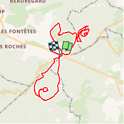

Length
22 km

Max alt
1240 m

Uphill gradient
691 m
Km-Effort
31 km

Min alt
927 m

Downhill gradient
696 m
Boucle
Yes
Creation date :
2019-09-30 06:19:05.859
Updated on :
2019-09-30 16:31:21.558
6h10
Difficulty : Difficult

FREE GPS app for hiking
 SityTrail
IGN / Geographical institutes
SityTrail Plus
The world is yours!
About
Trail Walking of 22 km to be discovered at Auvergne-Rhône-Alpes, Puy-de-Dôme, Orcines. This trail is proposed by jeanic63.
Description
départ rond point de vulcania
Positioning
Country:
France
Region :
Auvergne-Rhône-Alpes
Department/Province :
Puy-de-Dôme
Municipality :
Orcines
Location:
Unknown
Start:(Dec)
Start:(UTM)
496278 ; 5073269 (31T) N.
Comments