


Verfeil lac de la Balerme

tabouelle
User
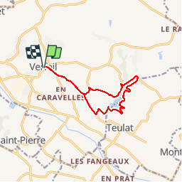

Length
12.1 km

Max alt
252 m

Uphill gradient
264 m
Km-Effort
15.7 km

Min alt
165 m

Downhill gradient
263 m
Boucle
Yes
Creation date :
2019-10-05 07:10:34.734
Updated on :
2019-10-05 11:13:32.443
4h01
Difficulty : Medium

FREE GPS app for hiking
 SityTrail
IGN / Geographical institutes
SityTrail Plus
The world is yours!
About
Trail Walking of 12.1 km to be discovered at Occitania, Haute-Garonne, Verfeil. This trail is proposed by tabouelle.
Description
12 km
Positioning
Country:
France
Region :
Occitania
Department/Province :
Haute-Garonne
Municipality :
Verfeil
Location:
Unknown
Start:(Dec)
Start:(UTM)
392053 ; 4834590 (31T) N.
Comments