


CHAMBOTTE (boucle)

Jean-Paulchoux
User
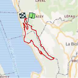

Length
15.1 km

Max alt
845 m

Uphill gradient
771 m
Km-Effort
25 km

Min alt
255 m

Downhill gradient
764 m
Boucle
Yes
Creation date :
2019-10-06 05:58:46.852
Updated on :
2019-10-10 08:22:16.949
5h49
Difficulty : Medium

FREE GPS app for hiking
 SityTrail
IGN / Geographical institutes
SityTrail Plus
The world is yours!
About
Trail Walking of 15.1 km to be discovered at Auvergne-Rhône-Alpes, Savoy, Entrelacs. This trail is proposed by Jean-Paulchoux.
Positioning
Country:
France
Region :
Auvergne-Rhône-Alpes
Department/Province :
Savoy
Municipality :
Entrelacs
Location:
Saint-Germain-la-Chambotte
Start:(Dec)
Start:(UTM)
723596 ; 5072930 (31T) N.
Comments