


MERU - CHARS

NUITEVEN
User
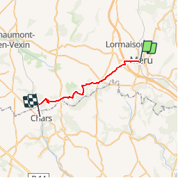

Length
23 km

Max alt
219 m

Uphill gradient
326 m
Km-Effort
27 km

Min alt
65 m

Downhill gradient
365 m
Boucle
No
Creation date :
2019-10-06 15:58:23.065
Updated on :
2019-10-07 09:12:12.619

FREE GPS app for hiking
 SityTrail
IGN / Geographical institutes
SityTrail Plus
The world is yours!
About
Trail of 23 km to be discovered at Hauts-de-France, Oise, Méru. This trail is proposed by NUITEVEN.
Positioning
Country:
France
Region :
Hauts-de-France
Department/Province :
Oise
Municipality :
Méru
Location:
Unknown
Start:(Dec)
Start:(UTM)
436792 ; 5453596 (31U) N.
Comments