


V2019.15.10 Dracy-Les-Couches randonnée douce

clabidault
User

Length
9.2 km

Max alt
454 m

Uphill gradient
195 m
Km-Effort
11.8 km

Min alt
338 m

Downhill gradient
195 m
Boucle
Yes
Creation date :
2019-10-06 17:10:54.455
Updated on :
2020-09-18 14:03:37.852
--
Difficulty : Very easy

FREE GPS app for hiking
 SityTrail
IGN / Geographical institutes
SityTrail Plus
The world is yours!
About
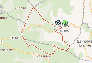
Trail On foot of 9.2 km to be discovered at Bourgogne-Franche-Comté, Saône-et-Loire, Dracy-lès-Couches. This trail is proposed by clabidault.
Positioning
Country:
France
Region :
Bourgogne-Franche-Comté
Department/Province :
Saône-et-Loire
Municipality :
Dracy-lès-Couches
Location:
Unknown
Start:(Dec)
Start:(UTM)
620154 ; 5193996 (31T) N.
Comments