


Tende à Saint Dalmas

petergole
User
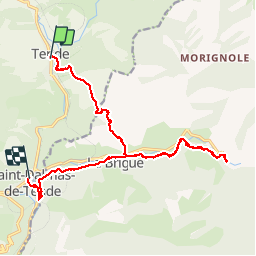

Length
19.6 km

Max alt
1126 m

Uphill gradient
821 m
Km-Effort
31 km

Min alt
672 m

Downhill gradient
947 m
Boucle
No
Creation date :
2019-10-07 07:19:28.0
Updated on :
2019-10-07 16:40:21.968
8h05
Difficulty : Medium

FREE GPS app for hiking
 SityTrail
IGN / Geographical institutes
SityTrail Plus
The world is yours!
About
Trail Walking of 19.6 km to be discovered at Provence-Alpes-Côte d'Azur, Maritime Alps, Tende. This trail is proposed by petergole.
Positioning
Country:
France
Region :
Provence-Alpes-Côte d'Azur
Department/Province :
Maritime Alps
Municipality :
Tende
Location:
Unknown
Start:(Dec)
Start:(UTM)
387421 ; 4882559 (32T) N.
Comments