


2019-10-09_07h33m35_StVictoire4-detente

ja.13061965
User
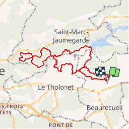

Length
19.5 km

Max alt
374 m

Uphill gradient
455 m
Km-Effort
26 km

Min alt
228 m

Downhill gradient
455 m
Boucle
Yes
Creation date :
2019-10-09 05:33:36.031
Updated on :
2019-10-09 05:33:36.849

FREE GPS app for hiking
 SityTrail
IGN / Geographical institutes
SityTrail Plus
The world is yours!
About
Trail of 19.5 km to be discovered at Provence-Alpes-Côte d'Azur, Bouches-du-Rhône, Beaurecueil. This trail is proposed by ja.13061965.
Positioning
Country:
France
Region :
Provence-Alpes-Côte d'Azur
Department/Province :
Bouches-du-Rhône
Municipality :
Beaurecueil
Location:
Unknown
Start:(Dec)
Start:(UTM)
705857 ; 4822120 (31T) N.
Comments