Maxent TA 10/10/2019

nolsim
User
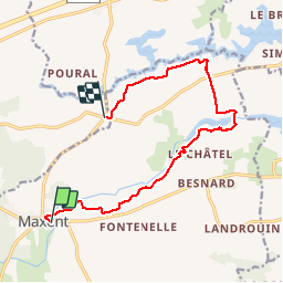

Length
11.8 km

Max alt
124 m

Uphill gradient
144 m
Km-Effort
13.7 km

Min alt
89 m

Downhill gradient
130 m
Boucle
No
Creation date :
2019-10-10 12:30:29.335
Updated on :
2019-10-10 15:15:10.808
2h44
Difficulty : Very easy

FREE GPS app for hiking
 SityTrail
IGN / Geographical institutes
SityTrail Plus
The world is yours!
About
Trail Walking of 11.8 km to be discovered at Brittany, Ille-et-Vilaine, Maxent. This trail is proposed by nolsim.
Positioning
Country:
France
Region :
Brittany
Department/Province :
Ille-et-Vilaine
Municipality :
Maxent
Location:
Unknown
Start:(Dec)
Start:(UTM)
572367 ; 5314770 (30T) N.
Comments