


Jambles mont Avril

clabidault
User
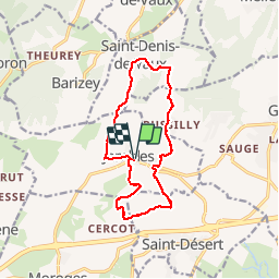

Length
12.8 km

Max alt
436 m

Uphill gradient
455 m
Km-Effort
18.8 km

Min alt
254 m

Downhill gradient
455 m
Boucle
Yes
Creation date :
2019-10-10 12:11:03.541
Updated on :
2019-10-10 19:25:34.819
--
Difficulty : Medium

FREE GPS app for hiking
 SityTrail
IGN / Geographical institutes
SityTrail Plus
The world is yours!
About
Trail On foot of 12.8 km to be discovered at Bourgogne-Franche-Comté, Saône-et-Loire, Jambles. This trail is proposed by clabidault.
Positioning
Country:
France
Region :
Bourgogne-Franche-Comté
Department/Province :
Saône-et-Loire
Municipality :
Jambles
Location:
Unknown
Start:(Dec)
Start:(UTM)
629467 ; 5181279 (31T) N.
Comments