


LE MONT RACHAIS

RD78-38
User
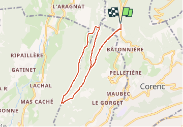

Length
8 km

Max alt
1043 m

Uphill gradient
357 m
Km-Effort
12.7 km

Min alt
764 m

Downhill gradient
357 m
Boucle
Yes
Creation date :
2014-12-10 00:00:00.0
Updated on :
2020-07-11 00:25:23.186
3h00
Difficulty : Unknown

FREE GPS app for hiking
 SityTrail
IGN / Geographical institutes
SityTrail Plus
The world is yours!
About
Trail Other activity of 8 km to be discovered at Auvergne-Rhône-Alpes, Isère, Corenc. This trail is proposed by RD78-38.
Positioning
Country:
France
Region :
Auvergne-Rhône-Alpes
Department/Province :
Isère
Municipality :
Corenc
Location:
Unknown
Start:(Dec)
Start:(UTM)
715932 ; 5012699 (31T) N.
Comments