


Mounier

PEBREJOSIANE
User
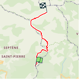

Length
9.3 km

Max alt
2791 m

Uphill gradient
1095 m
Km-Effort
20 km

Min alt
1745 m

Downhill gradient
54 m
Boucle
No
Creation date :
2014-12-10 00:00:00.0
Updated on :
2014-12-10 00:00:00.0
3h45
Difficulty : Medium

FREE GPS app for hiking
 SityTrail
IGN / Geographical institutes
SityTrail Plus
The world is yours!
About
Trail Walking of 9.3 km to be discovered at Provence-Alpes-Côte d'Azur, Maritime Alps, Péone. This trail is proposed by PEBREJOSIANE.
Positioning
Country:
France
Region :
Provence-Alpes-Côte d'Azur
Department/Province :
Maritime Alps
Municipality :
Péone
Location:
Unknown
Start:(Dec)
Start:(UTM)
336616 ; 4886198 (32T) N.
Comments
Départ de Valberg et non de Péone.Trés bon sentier régulier.